Mountain town on the Tara between Biogradska gora NP and Durmitor
Mojkovac lies in the valley of the Tara River, surrounded by the mountains of Bjelasica, Sinjajevina and Prošćenske planine, between the national parks of Biogradska gora and Durmitor. The town was founded during the reign of King Uroš I Nemanjić (1242–1276), when the nearby Brskovo was a mining and trading centre with the first silver mint. The canyon of the Tara River, which runs through the municipality, is the second deepest in the world and is part of the UNESCO-protected Durmitor National Park. In addition to its historical heritage, Mojkovac offers rafting, paragliding, fishing, hiking and cycling, while the warm hospitality of the local population makes it an authentic destination of Montenegro's north.
Location
Northeastern Montenegro
Elevation
853 m
Municipal population
8,622
Municipal area
367 km²
Founded
1242–1276
Climate
Moderate continental
Highlights
The stone bridge on the Tara River is located in the heart of Mojkovac, between the two bridges over the river, and is one of the most recognisable symbols of the town. Today it is best known for the international high-diving competition and as the starting point of the Adventure Race 'Northern Challenge'. The bridge has a rich history and provides direct access to the banks of the Tara, from where rafting tours and anglers depart. The surroundings of the bridge are ideal for walking and photography, especially on summer mornings when mist rises from the canyon.
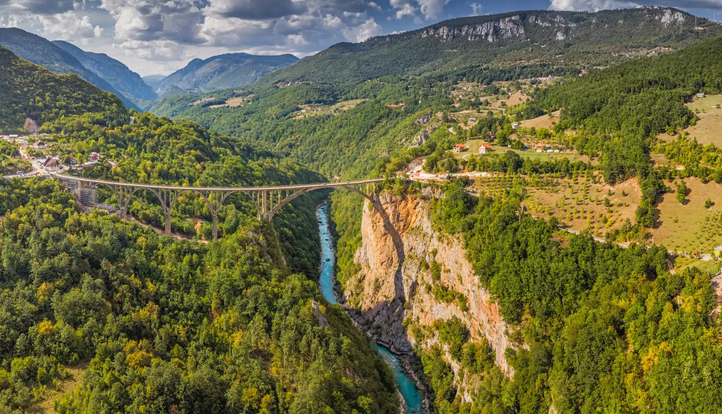
The Tara River Canyon runs through the municipality of Mojkovac and is the second deepest canyon in the world, between 900 and 1,300 metres deep and approximately 78 km long. It is an integral part of Durmitor National Park, which is inscribed on the UNESCO World Natural and Cultural Heritage list. Around 300 chamois live on the canyon walls, and in the canyon valley between Bistrica and Dobrilovina lies the virgin black pine forest Crna Poda, whose trees reach heights of up to 45 m and are on average 400 years old. The gorge of Đavolje Lazi, below the virgin forest, is where the course of the Tara narrows to just 2–3 metres.
Zabojsko Lake is located on the northeastern part of the Sinjajevina mountain, at an altitude of 1,477 metres. With a surface area of 27,600 m² and a maximum depth of around 19 metres, it ranks among the deepest mountain lakes in Montenegro. Surrounded by dense coniferous and beech forest, the lake is protected within Durmitor National Park under a strict protection regime. The waters are rich in trout and rare fish species, and the surrounding trails lead through the katun settlements of Sinjajevina.
Brskovo is located approximately 6 km east of Mojkovac and is one of the most important medieval sites in Montenegro. Founded in the 13th century, it was a mining and trading centre with the first silver mint, a caravan station between Kotor and Novo Brdo, and a consulate of the Republic of Dubrovnik. It was here in Brskovo that King Uroš I Nemanjić minted silver coins, which gave the town of Mojkovac its name. Stone walls, mining pits and the remains of a settlement have been uncovered at the site, bearing witness to the rich past of this region.
Located on the right bank of the Tara, near the stone bridge, this monument is the work of sculptor Drago Đurović and architect Mirko Đukić, erected in 1966 to mark the 50th anniversary of the famous Battle of Mojkovac. On Christmas Day 1916, the Montenegrin army under the command of Serdar Janko Vukotić defeated the far superior Austro-Hungarian army, in one of the most significant battles in the history of Montenegro and the First World War. Today this monument is a symbol of the town and a must-visit for all who wish to understand the history of Montenegro's north.
What to do
The Tara River offers one of the most spectacular rafting experiences in Europe, with 69 rapids and 40 waterfalls through a UNESCO-protected canyon.
tap to closeLaunch sites around Mojkovac offer ideal conditions for paragliding throughout the year, with stunning views over the Tara Canyon and surrounding mountains.
tap to closeExtensive trail networks across Bjelasica and Sinjajevina offer hiking for all levels, from gentle walks to summit ascents reaching over 2,100 m.
tap to closeThe crystal-clear waters of the Tara are rich in trout, making it one of Montenegro's premier fishing destinations.
tap to closeMountain biking trails around Mojkovac, Bjelasica and Sinjajevina cater to both casual cyclists and experienced riders.
tap to closeExplore the medieval archaeological site of Brskovo and the Monument to the Heroes of the Battle of Mojkovac to discover the rich history of Montenegro's north.
tap to closeDid You Know?
The Tara River Canyon, which runs through the municipality of Mojkovac, is the second deepest canyon in the world — between 900 and 1,300 metres deep — and is protected as part of UNESCO's World Heritage. Second deepest canyon in the world
Plan Your Visit
Phone
+382 50 680 195Website
mojkovac.travelTuristički informativni centar: svaki dan 08:00–20:00 (adresa: 21. maja, između dva mosta na Tari). Opštinska uprava: pon–pet 08:00–15:00.
Ulaz u grad besplatan. Boravišna taksa naplaćuje se prema kategoriji smještaja; djeca do 12 godina ne plaćaju, od 12 do 18 godina plaćaju 50% iznosa.
Parkiranje dostupno u centru grada, u blizini kamenog mosta na Tari.
Centar grada je uglavnom pristupačan za osobe sa smanjenom pokretljivošću. Planinske staze i kanjon Tare zahtijevaju dobru fizičku kondiciju.
FAQ