Mountain town in northeastern Montenegro, at 1,000 m
Rožaje lies at an altitude of around 1,000 metres, in the valley of the Ibar river, surrounded by the mountain massifs of Hajla, Mokra Gora, and Štedim. The town is a natural crossroads between Montenegro, Serbia, and Kosovo, with a rich Ottoman heritage reflected in its architecture, traditions, and culture. The surrounding area offers unspoiled nature — forested zones, mountain pastures, and numerous springs ideal for hiking, cycling, and mountaineering throughout the year. Mount Hajla, which forms the southern boundary of the Rožaje basin, is particularly prized as a botanical garden full of medicinal herbs, blueberries, and wild forest fruits.
Location
Northeastern Montenegro
Altitude
approx. 1,000 m
Population
approx. 22,000
Municipality Area
approx. 432 km²
Annual Humidity
70–80%
Historical Heritage
Ottoman Era
Highlights
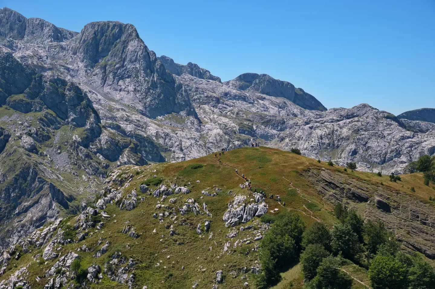
Hajla is located in the far east of Montenegro and stretches along the border with Kosovo, between the Rugova Gorge and the source of the river Ibar. It forms the southern boundary of the Rožaje basin and is one of the most impressive natural landscapes in the region. The mountain has been described as a true botanical garden — medicinal herbs, blueberries, rosehips, juniper, and wild strawberries grow along its trails. A visit in late summer offers the opportunity to pick wild forest fruits while enjoying panoramic views of the surrounding mountain massifs.
Rožaje became a significant centre during Ottoman rule, which lasted for several centuries, and it was during this period that many of the sacred and historical structures still visible today were formed. The development of the čaršija, crafts, and trade routes contributed to the town's economic growth and shaped the urban structure that forms the basis of today's town centre. The Ottoman legacy has left its mark on the architecture, traditions, and customs of the local population. A walk through the town centre reveals layers of history that bear witness to Rožaje's role as an important caravan and administrative hub in the Balkans.
Rožaje is situated in the valley of the river Ibar, one of the key rivers of the Balkans, whose source lies in the vicinity of this very town. The Ibar flows through the town and provides a natural setting for walks and time spent in nature. Thanks to this position, Rožaje has always held a strategic role as a natural link between Montenegro, Serbia, and Kosovo. The surrounding forested areas and mountain pastures along the river are well suited for hiking and outdoor activities throughout the year.
Mokra Gora is one of the mountain massifs surrounding Rožaje and forms part of the impressive mountain frame of the Rožaje basin. Together with Hajla and Štedim, Mokra Gora creates a natural barrier that gives Rožaje its mountain climate, with cool summers and cold winters. The massif offers hiking and mountain biking trails of varying difficulty, from gentle forest routes to more demanding sections. Rich forested areas and mountain pastures make this space ideal for exploration in all seasons.
What to do
Explore trails on Mount Hajla and Mokra Gora with panoramic views.
tap to closeRide through forest clearings, valleys, and mountain peaks on well-marked trails.
tap to closeTackle the steep trails and rock faces of the high massifs of Hajla and Mokra Gora.
tap to closeEnjoy winter sports on groomed mountain slopes in the Rožaje area.
tap to closeGather blueberries, rosehips, juniper, and medicinal herbs on Mount Hajla.
tap to closeDid You Know?
Mount Hajla, which forms the southern boundary of the Rožaje basin, is often described as a botanical garden — medicinal herbs, blueberries, rosehips, and juniper grow along almost every trail. botanical garden
Plan Your Visit
Grad je dostupan tokom cijele godine. Turistička organizacija Rožaje radi radnim danima.
Centar grada je uglavnom pristupačan, dok planinski tereni zahtijevaju dobru fizičku kondiciju.
FAQ