A short gravel ride above Andrijevica with a view from the Željevica Viewpoint.
Trail AN03a is 3.8 km long and follows a gravel road with a gradual climb of 229 m. It is easy and suitable for cyclists looking for a short but rewarding ride in the highlands above Andrijevica.
Trail AN03a is a short gravel route, 3.8 km long, ridden in one direction. The lowest point is at 1,229 m a.s.l. and the highest at 1,421 m a.s.l., with a total ascent of 229 m and a descent of 78 m. The surface is gravel throughout, making the trail accessible even to those who are just getting into gravel cycling.
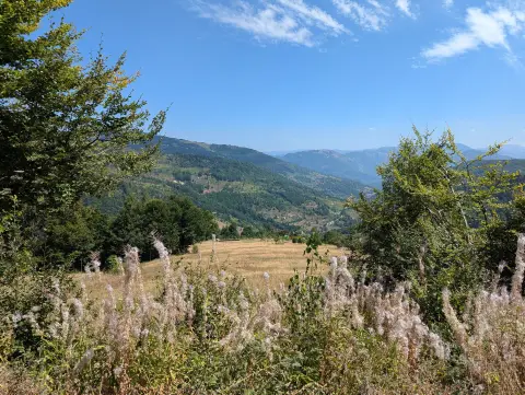
Already at 1.7 km from the start, you reach the Željevica Viewpoint (1,400 m a.s.l.), which offers a beautiful view of the surrounding mountain landscape. It is a great spot for a short break before continuing the ride.
Near the end of the trail, at 3.6 km, there is a drinking water fountain at an elevation of 1,356 m — a welcome refreshment stop in the final stretch of the route.
The estimated riding time without breaks is 45 minutes. The trail is rated as easy and is recommended for cyclists of all ages looking for a peaceful ride through the mountain scenery above Andrijevica.
What this difficulty means
Mostly flat or gentle riding on good surfaces. Fine for occasional riders and families.
Places on this route
Move along the profile to follow the route on the map; switch on 3D for the terrain.
↑ 229 m · ↓ 78 m · highest point 1,421 m
Along the way
At 1.7 km from the start, at 1,400 m a.s.l., it offers a view of the mountain landscape. An ideal spot for a short rest and photography.
At 3.6 km from the start of the trail, at 1,356 m a.s.l., there is a drinking fountain — a welcome refreshment just before the end of the ride.
The trail is entirely gravel-surfaced, making it suitable for gravel bikes and pleasant to ride without any asphalt sections.
Bring enough water, even though a fountain exists near the end of the trail — it is always safer to have a reserve in your bottle.
The trail is ridden in one direction, so arrange transport in advance or plan your return to the starting point.
A gravel or MTB bike is recommended due to the gravel surface throughout.
Set off earlier in the morning to avoid afternoon mountain thunderstorms, which are common in summer at these elevations.
Bring a windproof jacket — above 1,400 m it can be cold even in the warmer months.
Check the condition of the gravel road after heavy rain, as the paths may be slippery or damaged.
The trail is located at elevations between 1,229 and 1,421 m, where weather conditions can change rapidly — especially in summer, when sudden thunderstorms are common. In case of emergency, call the single emergency number: 112.
Emergency number in Montenegro: 112.
Good to know
Best season
The trail is best from late spring to early autumn, approximately from May to October. In winter months the gravel road may be covered with snow or ice, making riding unsafe.
Getting there
The nearest town to the start of the trail is Andrijevica, approximately 5.2 km away. The easiest way to reach the starting point is by private vehicle.
The trail is 3.8 km long and is ridden in one direction.
The estimated duration without breaks is 45 minutes.
The trail is rated as easy, with a total ascent of 229 m and a 100% gravel surface.
At 3.6 km from the start there is a fountain with drinking water at 1356 m a.s.l. However, it is recommended to set out with enough water in a bottle.
44.2 km↑ 1,188 m3½–5 h
Loop29.5 km↑ 1,189 m8½–12 h
16.9 km↑ 353 m1–1½ h
Loop28.6 km↑ 619 m2½–4 h
44.4 km↑ 1,523 m4–5½ h
22.8 km↑ 1,330 m7½–10½ h
6.9 km↑ 164 m30–40 min
Loop22.0 km↑ 1,238 m6½–9½ h
Times and grades are estimates. Conditions change: check the weather and local information before you set out.

Ask about Montenegro
Ask me about destinations, restaurants or activities.
