A short mountain tour through the forest to the distinctive pass at 1,674 m above sea level.
The trail, 3.4 km long, leads through forested terrain to Krvavac Pass (1,674 m a.s.l.). It is of moderate difficulty, with an ascent of 232 m, and the walk takes about 1 h 20 min without breaks.
The trail starts at an altitude of 1,449 m and runs in one direction to Krvavac Pass at 1,674 m a.s.l. The total length is 3.4 km, and the terrain is entirely an earthen forest path — well passable, but requiring sturdy footwear.
At 2.1 km from the start you reach the Spring (1,533 m a.s.l.), a useful spot for a short rest. The trail continues uphill to Krvavac Pass at 2.7 km, which is also the highest point of the route (1,674 m a.s.l.). From there, open views of the surrounding mountain landscape unfold.
The trail is marked and classified as moderate (SAC T2), meaning it is suitable for hikers with basic experience and appropriate equipment. The endpoint is not in the same place as the start, so transport or the return journey must be arranged in advance.
What this difficulty means
Longer or steeper sections and uneven ground. You need basic fitness, sturdy shoes and a little mountain experience.
Mountain hiking grade SAC T2 (scale T1–T6).
Places on this route
Move along the profile to follow the route on the map; switch on 3D for the terrain.
↑ 232 m · ↓ 84 m · highest point 1,674 m
Along the way
At 2.1 km from the start there is a spring that serves as a natural rest point in the middle of the ascent.
The highest point of the trail at 2.7 km from the start. The pass offers open views of the mountain landscape.
The entire route passes through forested terrain on an earthen surface — a pleasant walk in a natural setting.
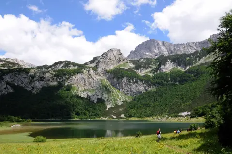
About 4.7 km from the trail lies Trnovačko jezero, which you can visit as an additional destination for your outing.
Bring enough water — do not rely on springs along the trail as your only source of supply.
Use mountain footwear with good grip, as the terrain is earthen and can be slippery after rain.
The trail is one-way — arrange transport in advance or organise a second vehicle at the endpoint.
Set out in the morning to avoid afternoon thunderstorms, which are common on mountains during the summer months.
Bring a warm layer of clothing — at Krvavac Pass (1,674 m) it can be cooler and windy.
Follow the trail markings along the entire route and do not stray from the marked path.
Mountain weather can change quickly — in the event of a thunderstorm, seek shelter and do not remain on exposed ridges. Fog can reduce visibility, so follow the trail markings. In case of emergency, call 112.
Emergency number in Montenegro: 112.
Good to know
Best season
The trail is most accessible from late spring to early autumn, roughly from May to October. Outside that period, snow and ice may be present on terrain above 1,500 m.
Getting there
The nearest larger lake in the area is Stabanska jezera, about 4.1 km from the trailhead. It is recommended to arrive by your own vehicle and to arrange parking near the starting point.
The trail is 3.4 km long and runs in one direction, from the start to Krvavac Pass.
The estimated walking time without breaks is 1 h 20 min. Allow somewhat more time when including breaks.
The trail is of moderate difficulty (SAC scale T2). Basic hiking experience and appropriate equipment are recommended.
Yes, the trail is marked along the entire route.
0.5 km↑ 82 m15–25 min
1.7 km↑ 262 m55–80 min
4.2 km↑ 291 m1½–2 h
4.0 km↑ 628 m2½–3 h
0.9 km35–50 min
9.1 km↑ 1,558 m5½–8 h
2.3 km↑ 14 m1½–2 h
1.0 km↑ 98 m25–35 min
Times and grades are estimates. Conditions change: check the weather and local information before you set out.

Ask about Montenegro
Ask me about destinations, restaurants or activities.
