The Bistrica canyon below the Pešter plateau
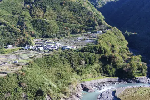
The Đalovića Gorge is cut into limestone on the western edge of the Pešter plateau and runs for about 8 km, down to Podvrh Monastery, 25 km north-east of Bijelo Polje.
It is deepest, about 600 metres, at the Juriško spring, where the Bistrica river bursts from the rock. It has been protected as a natural monument since 1968. From Podvrh a forest trail leads upstream to the Cave above Vražji Firovi, the longest known cave in Montenegro. The upper part of the gorge lies in Serbia; the lower part, with the spring, the cave and the monastery, is in Montenegro.
Highlights
At the very end of the gorge, where the canyon is deepest – about 600 metres – the Bistrica bursts from the rock at the Juriško spring. A dye test in the 1960s established that the water emerging here sinks on the Pešter field, on the far side of the plateau. The spring is on the trail from Podvrh, about 1.2 km from the start.
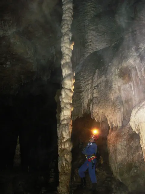
In the middle part of the gorge, on the left side of the canyon, opens the Cave above Vražji Firovi – with about 20 km of explored passages, the longest known cave in Montenegro. You can hike to the entrance from Podvrh, but the inside is not set up for visitors and only experienced cavers go in.
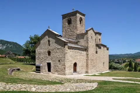
Explore MoreThe Church of St Nicholas at the mouth of the gorge was built in 1606. From outside it looks like a village house with a tall shingle roof, and its dome can only be seen from inside. The frescoes were painted in 1613/14 by the priest Strahinja of Budimlja, and the gilded iconostasis dates from 1665. In 1960 the 14th-century Divoš Gospel was found in the church; it is now kept in Cetinje.
From Podvrh the trail climbs upstream, along the Bistrica and through forest, past the Juriško spring to Vražji Firovi and the cave entrance. It is about 3.3 km long with about 230 metres of ascent; one way takes about two hours. You return the same way.
Explore MoreFor its natural features and beauty the gorge was protected in 1968 as a natural monument, covering about 1,106 hectares. The lower part, with the spring, the cave and the monastery, belongs to Bijelo Polje municipality; the upper part, towards the Pešter plateau, belongs to Sjenica municipality in Serbia.
What to do
About 3.3 km from Podvrh Monastery, through forest and past the Juriško spring, to the cave entrance.
The Church of St Nicholas from 1606, with frescoes by the priest Strahinja and an iconostasis from 1665.
The Bijelo Polje Tourist Organisation marked a riverside trail from the village of Bistrica to Podvrh; ask about its condition before you go.
The steep limestone walls, the spring and the forest look best in spring, when the water is highest, and in autumn.
Hiking, walking and cycling routes that start here or pass nearby, with maps and GPX downloads.
The 3.3 km trail leads through Đalovića Gorge to Đalovića Cave at 876 m a.s.l. An earthen surface and moderate ascent make it easy and suitable for the whole family.
3.3 km229 m2½–3½ h
View trailA cycling route 110.7 km long with 2882 m of ascent. It leads from Rožaje through the Pešter region, with viewpoints, peaks and water fountains; very demanding and intended for experienced riders.
111 km2,882 m2–3 days
View trailThe BP02 cycling route is 51.4 km long and runs point-to-point through the surroundings of Bijelo Polje. It has a total ascent of 1468 m, a total descent of 880 m, and an estimated duration of 6 h 20 min without breaks.
51.4 km1,468 m5½–7½ h
View trail
A demanding one-way cycling route 398,8 km long, with a total ascent of 9352 m. It passes through Biogradska Gora National Park and Durmitor National Park, past Bijelo Polje, Kolašin, Nikšić and Žabljak.
399 km9,352 m5–8 days
View trail
The Brzava – Šiško Lake hiking trail is 26.3 km long and leads through Biogradska Gora National Park. With 1589 m of ascent and the highest point at 2011 m above sea level, it is intended for experienced hikers.
26.3 km1,589 m8½–11½ h
View trailPlan your stay
Live offers from local hosts on our booking platform. Nothing is charged online — you pay the host on site.
Booking requests are confirmed by the host; payment on site. Offers come from the Travel to Montenegro booking platform.
Plan Your Visit
Admission
There is no charge to enter the gorge.
Parking
Leave the car at Podvrh Monastery, at the end of the road.
Phone
+382 50 433 711Website
www.tobp.meThe gorge is open countryside with no opening hours. Start early so you are back before dark.
A forest trail with an ascent and steep sections in places; not suitable for pushchairs or wheelchairs.
FAQ
Around here
Explore More