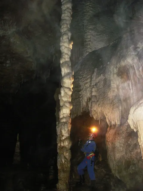
A forest trail through the gorge to an impressive cave, accessible to hikers of all ages.
The 3.3 km trail leads through Đalovića Gorge to Đalovića Cave at 876 m a.s.l. An earthen surface and moderate ascent make it easy and suitable for the whole family.
The trail starts from the lowest point at 689 m a.s.l. and follows the gorge northward. The surface is entirely earthen and forest trail, pleasant for walking in all seasonal conditions.
At about 1.2 km from the starting point you encounter Juriško Spring (717 m a.s.l.) — a natural spring that is a good sign you are on the right path. From there the trail continues uphill, with a total ascent of 229 m through dense forest vegetation.
The destination of the tour is Đalovića Cave (886 m a.s.l.), located at the very end of the trail. The return is made along the same route, so the total distance covered is 3.3 km one way.
The trail is rated as easy and suits recreational walkers, families with children, and anyone who wants a pleasant outing in nature without special hiking equipment.
What this difficulty means
Well-made paths with gentle gradients. Fine for families and anyone used to walking a few hours.
Move along the profile to follow the route on the map; switch on 3D for the terrain.
↑ 229 m · ↓ 138 m · highest point 876 m
Along the way
Photos and short clips from points along the route — tap one to open it.
The final destination of the trail at 886 m a.s.l., 3.3 km from the starting point. The cave is the main attraction of this outing.
A natural spring at 717 m a.s.l., reached after about 1.2 km of walking. A lovely intermediate goal and a place for a short rest.
The entire trail runs along an earthen and forest surface through Đalovića Gorge, providing pleasant shade and an attractive landscape throughout the walk.
Bring enough water, especially in warmer weather.
Footwear with good grip is recommended, as the surface is earthen and can be slippery after rain.
Set off earlier in the morning to avoid afternoon showers, which are common in the summer months.
Estimate the walking time without breaks at around 2 h 45 min — allow extra time for rest and exploring the cave.
Bring a light jacket, as it can be cooler in the gorge and inside the cave than in the open.
In the event of a sudden change in weather or thunder, take shelter from open terrain and do not enter the cave without appropriate equipment and company. Mobile signal may be weak in the gorge. In an emergency, call 112.
Emergency number in Montenegro: 112.
Good to know
Best season
The trail is most pleasant from March to June and from September to November, when temperatures are moderate and vegetation is lush. In summer it is passable, but an early start is recommended due to the heat.
Getting there
The trailhead is located in Đalovića Gorge at 689 m a.s.l. For precise directions on how to get there, we recommend checking current information on-site or with local guides.
The trail is 3.3 km one way. Since you return along the same route, you cover a total of 6.6 km.
The estimated walking time without breaks is 2 h 45 min. With rest stops and exploring the cave, allow somewhat more time.
The trail is rated as easy. The total ascent is 229 m, and the surface is entirely earthen and forest trail.
The recommended months are March, April, May, June, September, October, and November. Summer is possible, but afternoon heat and showers can be unpleasant.
111 km↑ 2,882 m2–3 days
51.4 km↑ 1,468 m5½–7½ h

399 km↑ 9,352 m5–8 days
26.3 km↑ 1,589 m8½–11½ h
17.3 km↑ 1,380 m6–9 h
44.2 km↑ 1,794 m5½–8 h
22.8 km↑ 1,540 m7½–10½ h
39.0 km↑ 1,580 m5–7 h
Times and grades are estimates. Conditions change: check the weather and local information before you set out.

Ask about Montenegro
Ask me about destinations, restaurants or activities.