A loop hiking trail along a forest path to the summit of Međeđi vrh, with a spring and an ascent of 725 m.
The Međeđi vrh trail is a loop hiking trail 6.4 km long. With moderate difficulty (SAC T2) and an ascent of 725 m, it leads along a forest path to the summit of Međeđi vrh and back to the starting point.
The Međeđi vrh trail is a loop hiking trail 6.4 km long. It starts and ends at the same point, at the lowest point of the trail (1,582 m a.s.l.). The highest point of the trail is at 2,131 m a.s.l., and the total ascent and descent are 725 m and 723 m respectively. Allow approximately 4 hours and 40 minutes for the circuit without breaks.
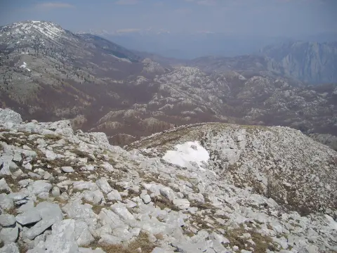
The entire trail runs on dirt and forest terrain and is marked in green. At 2.9 km from the starting point there is a spring at 1,687 m a.s.l., and the destination of the tour is the summit of Međeđi vrh at 2,139 m a.s.l., reached at 6.4 km from the start.
The tour is of moderate difficulty (SAC T2) and is suitable for hikers with basic fitness. Nearby are Manito jezero (about 8.4 km from the trail) and Kapetanovo jezero (about 9.6 km). Due to the elevation differences and altitude above 2,000 m, the weather can change quickly.
What this difficulty means
Longer or steeper sections and uneven ground. You need basic fitness, sturdy shoes and a little mountain experience.
Mountain hiking grade SAC T2 (scale T1–T6).
Places on this route
Move along the profile to follow the route on the map; switch on 3D for the terrain.
↑ 725 m · ↓ 723 m · highest point 2,131 m
Along the way
The point at the end of the loop tour, at 6.4 km from the start of the trail.
Located 2.9 km from the start of the trail, suitable for a short rest.
The entire trail, 6.4 km long, has a dirt/forest surface with a total ascent of 725 m and descent of 723 m.
Bring enough water, especially during the summer months.
Footwear should be hiking boots, as the surface is 100% dirt/forest terrain.
Due to the altitude above 2,000 m, bring layered clothing and rain protection.
Plan an early start – the estimated duration without breaks is 4 h 40 min.
Check the weather forecast before you set out.
There is a spring on the trail at 2.9 km, but always carry reserve water.
The trail climbs above 2,000 m a.s.l.; the weather can change quickly, so bring warm, layered clothing. In the event of a storm or fog, do not leave the marked route. For emergencies in Montenegro, call 112.
Emergency number in Montenegro: 112.
Good to know
Best season
The most favourable period is from late spring to early autumn. On sections above 2,000 m snow may persist until late spring, and summer mornings tend to be cooler.
Getting there
The trail is a loop, so the start and end are at the same location. Use hiking maps for precise access directions.
The trail is 6.4 km long and is a loop.
The estimated duration without breaks is 4 h 40 min.
The difficulty is moderate and it is rated T2 on the SAC hiking scale.
Yes, the trail is marked in green.
2.7 km↑ 444 m1½–2½ h
9.8 km↑ 1,370 m6–8½ h
44.2 km↑ 463 m2–3 days
13.0 km↑ 25 m4–5½ h

399 km↑ 9,352 m5–8 days
38.7 km↑ 392 m2–3 days
12.7 km↑ 782 m4–5½ h
12.1 km↑ 976 m4½–6½ h
Times and grades are estimates. Conditions change: check the weather and local information before you set out.

Ask about Montenegro
Ask me about destinations, restaurants or activities.
