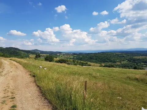
An easy 8 km cycling tour with a mixed asphalt-macadam surface and gentle climbs.
An easy one-way cycling trail 8.0 km long, with 119 m of ascent. It is ridden on asphalt and macadam at an altitude of 1220–1304 m, with an estimated duration of 45 min without breaks.
The PV11 cycling trail is 8.0 km long and runs in one direction. The start is about 4.4 km from Pljevlja, and the ride takes approximately 45 minutes without breaks. The trail is not circular, so the start and finish are not in the same place.
The trail is easy, with a total ascent of 119 m and a descent of 118 m. The lowest point is at 1220 m above sea level, and the highest at 1304 m above sea level, a difference of only 84 m. The surface is mixed: 56% asphalt/concrete and 44% macadam, making it a good choice for trekking bikes as well.
Near the trail, about 9.7 km away, is the Ćehotina Meanders Viewpoint. The ride is suitable for recreational cyclists and families looking for a shorter ride at a moderate altitude. The trail is marked, and due to the mixed surface, caution is recommended on the macadam.
What this difficulty means
Mostly flat or gentle riding on good surfaces. Fine for occasional riders and families.
Places on this route
Move along the profile to follow the route on the map; switch on 3D for the terrain.
↑ 119 m · ↓ 118 m · highest point 1,304 m
The total ascent is 119 m and the descent is 118 m, so the ride is easy.
View of the Ćehotina meanders, about 9.7 km from the trail.
The start of the trail is approximately 4.4 km from Pljevlja.
Bring enough water.
Because of the 44% macadam, use a trekking bike or a bike with wider tires.
Check the weather forecast before the ride; at 1220–1304 m the weather can change quickly.
The trail is one-way, so arrange your return or alternative transport in advance.
A helmet is mandatory, and in summer plan your ride in the morning or early evening.
The ride takes place at 1220–1304 m above sea level, so bring layered clothing. In case of thunderstorm or fog, stop the ride. In an emergency, call 112.
Emergency number in Montenegro: 112.
Good to know
Best season
The best period for riding is from late spring to early autumn, when the trails are dry and temperatures are moderate. In winter and after heavy rainfall, the macadam can be muddy.
Getting there
The most practical way to reach the start of the PV11 trail is from Pljevlja, about 4.4 km away.
The trail is 8.0 km long and runs in one direction.
The estimated duration without breaks is 45 minutes.
The trail is easy, with a total ascent of 119 m and a descent of 118 m.
The surface is mixed: asphalt/concrete 56 % and macadam 44 %.
19.2 km↑ 770 m2–2½ h
50.9 km↑ 1,081 m3½–5 h
37.0 km↑ 1,617 m5–7 h
36.9 km↑ 757 m2½–3½ h
13.9 km↑ 160 m65–90 min
14.5 km↑ 529 m1½–2 h
15.6 km↑ 402 m1½–2 h
13.4 km↑ 279 m1–1½ h
Times and grades are estimates. Conditions change: check the weather and local information before you set out.

Ask about Montenegro
Ask me about destinations, restaurants or activities.
