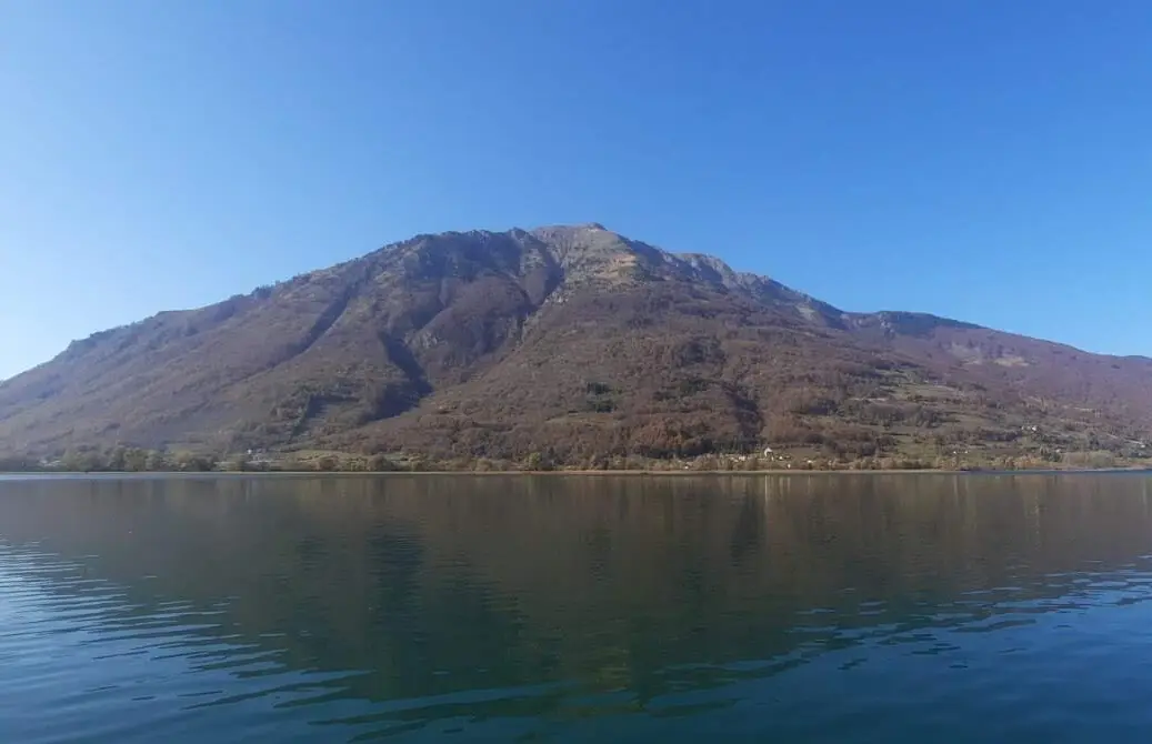
A multi-day hiking traverse along the Visitor ridge with panoramic summits above Plav and Andrijevica.
A demanding linear route of 24.6 km leads from Andrijevica along the Visitor ridge to the mountain of the same name, with a total ascent of 2054 m. The trail is intended for experienced hikers and is recommended as a multi-day undertaking.
The trail starts in Andrijevica (756 m a.s.l.) and gradually climbs through forested terrain towards the Stubica pass (1490 m a.s.l.) at 6.9 km from the start. In the initial section of the trail there are four water fountains, which makes hydration easier in the lower zones.
After Stubica the terrain becomes more open and steeper. At 10.2 km is the Pločice Viewpoint (1911 m a.s.l.), from which a view of the surrounding mountain landscape opens up. Further on, the trail passes the summits of Goveđak (2039 m a.s.l.) and Rogovi (2012 m a.s.l.), and at 13.7 km a spring is available at 1915 m a.s.l.
The second half of the route follows the ridge at elevations above 1900 m. The trail crosses the Drekina kosa pass (1916 m a.s.l.), the summit of Misa (1931 m a.s.l.), and continues towards Vrh Somina (2138 m a.s.l.) and Maja e Ljugu Bors (2173 m a.s.l.). At 19.4 km a water fountain is available at 1968 m a.s.l. The trail ends near the summit of Bandera (Krivi smet) (2211 m a.s.l.).
The trail is marked with red-and-white waymarks and is recommended exclusively for experienced hikers with appropriate equipment and a plan for a multi-day stay in the mountains.
What this difficulty means
Very long or alpine terrain where hands may be needed, with few ways out. Only for experienced mountaineers in stable weather.
Places on this route
Move along the profile to follow the route on the map; switch on 3D for the terrain.
↑ 2,054 m · ↓ 675 m · highest point 2,174 m
Along the way
At 10.2 km from the start, a wide view opens up over the mountain landscape around Visitor. A good point for a short break and orientation.
One of the first high summits on the route, reached at 11.0 km from the start of the trail.
The central section of the route travels above 1900 m a.s.l. through open mountain terrain with views of the surrounding valleys and summits.
The final summits of the route at elevations above 2170 m represent the crown of this mountain traverse.
Several water fountains and one spring have been recorded along the trail, distributed from the lowest sections (790 m a.s.l.) up to an elevation of 1968 m a.s.l., which is significant for planning water resupply.
Plan the tour as a multi-day trip – the estimated walking time without breaks is 11 h 15 min.
Carry enough water and food for the whole day; replenish your water supply at the marked fountains and spring along the trail.
Start early in the morning so that you can cross the exposed ridge sections before any potential afternoon thunderstorms.
At elevations above 1900 m the terrain is open and exposed – carry a windproof jacket and warm spare clothing.
The trail is one-way – arrange transport to the start and from the end point in advance.
Use hiking boots with good grip; the dominant surface is dirt and forest trail (76 %), but there are also asphalt and gravel road sections.
The trail passes through long sections above 1900 m a.s.l. over open terrain exposed to sudden weather changes, fog and thunderstorms. Monitor the weather forecast and do not set out if storms are forecast. In case of emergency call the emergency services on 112.
Emergency number in Montenegro: 112.
Good to know
Best season
The recommended period is from late spring (June) to early autumn (September), when the ridge section of the trail is free of snow and passable. Outside this period the higher parts of the route may be covered in snow or ice.
Getting there
The trail begins in Andrijevica, which is located approximately 0.4 km from the starting point. Andrijevica can be reached by road; upon arrival, make your way to the marked trail start.
The trail is 24.6 km long. The estimated walking time without breaks is 11 h 15 min, which is why it is recommended as a multi-day tour.
The trail is rated as very demanding and is intended for experienced hikers. The total ascent is 2054 m, and the highest point is 2174 m above sea level.
Yes, the trail is marked with red-and-white trail markers along the entire route.
Due to the altitude (up to 2174 m above sea level), the safest period is from late spring to early autumn, when there is no snow on the ridge and the days are longer.
Cycling · Andrijevica
Cycling · Andrijevica
Cycling · Andrijevica
Hiking · Andrijevica · Prokletije National Park
Cycling · Andrijevica
Hiking · Andrijevica
Cycling
Cycling · Andrijevica
Times and grades are estimates. Conditions change: check the weather and local information before you set out. Map and data sources →

